The Transportation Department plans and manages smaller, transportation projects.
The Capital Projects Department primarily focuses on the consistent delivery of all of the City’s major capital projects. For the most up to date information on projects, visit the Capital Improvement Projects page.
2024 PROJECTS
MISCELLANEOUS REPLACEMENT OF TRAFFIC SIGNAL INFRASTRUCTURE
The City owns and operates 24 traffic signals. There are an additional 17 traffic signals that are owned and operated by the BC Ministry of Transportation and Infrastructure. As these signals age, they require replacement. The City will replace various parts of various traffic signals (signal heads, poles, controllers etc). Drivers can expect some minor traffic disruption. Operation of the signals will not change.
The following improvements are planned:
New signal heads at Highway 19A / Erickson Road
2 new poles at Dogwood Street / 9th Avenue - includes new right turn arrow for eastbound traffic
1 new pole at Dogwood Street / 4th Avenue
1 new pole at Dogwood Street / Merecroft Road
SOUTH ALDER STREET / HILCHEY ROAD: TRAFFIC SIGNAL REPLACEMENT
The traffic signal at South Alder Street and Hilchey Road is planned for a full replacement in 2024. The signal is aging and in need of a complete replacement. This project will include new bases, new poles, new arms, new signal heads, a new controller box, new street lights, an accessible pedestrian system, pedestrian countdown timers, an emergency vehicle pre-emption system and new vehicle sensors. In addition, the City will install a protected left turn arrow for southbound traffic.
MASTER TRANSPORTATION PLAN
The City continues its update of the Master Transportation Plan. The MTP is a guiding document that shapes transportation for the next 20 years. It will recommend improvements to walking, cycling, transit and road infrastructure to accommodate growth in our community. The current MTP was completed in 2012 by Urban Systems.
The Plan is in the third phase - the Draft and Final Plan.
For more information and to Get Involved in this process, visit getinvolved.campbellriver.ca.
BIRCH STREET BIKEWAY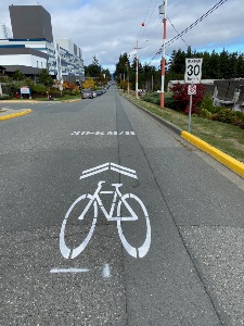
The City of Campbell River has upgraded Birch Street to a neighbourhood bikeway. Neighbourhood bikeways are typically streets with low motor vehicle volumes and speeds and do not contain bike lanes. Based on low volumes and speeds, they are comfortable for all ages and all abilities.
The Birch Street neighbourhood bikeway will provide a key connection from downtown to near the north end of the Dogwood Street multi-use pathway and will connect several key destinations including Robron Centre, Robron Park, Pinecrest Elementary School, the hospital, Centennial Park, Ecole Phoenix Middle School and downtown.
The speed limit along the Birch Street neighbourhood bikeway has been lowered to 30 km/hr and the pavement has been marked with 'sharrows.'
The City will now look at introducing traffic calming measures to further encourage drivers to slow down. The City completed an online survey to gather feedback from residents, pedestrians, cyclists and drivers.
NEW BC TRANSIT BUS SHELTERS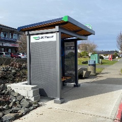
The City has yearly funding to install bus shelters at various locations around Campbell River. Cost to the City is offset by funding from BC Transit.
These locations have new shelters, installed in 2024:
16th Avenue, eastbound, west of Dogwood Street
South Island Highway, southbound, at Willow Point Mall
These locations are planned for new shelters, in 2024:
16th Avenue, eastbound, between Petersen Road and Maple Street
South Dogwood Street, northbound, at Merecroft Road
South Alder Street, northbound, at Yorkshire Drive
In addition, these locations have new shelters in 2024, and were fully funded by a grant from the BC Ministry of Transportation and Infrastructure. The City runs the bus service south of town, along Highway 19A to Oyster River, where residents can transfer onto the Comox Valley system into Courtenay.
Highway 19A, northbound, at York Road
Highway 19A, northbound, at Lynnwood Road
Highway 19A, northbound, at Seawave Road
Highway 19A, northbound, at McGimpsey Road
NEW UPGRADED CROSSWALKS
The City is reviewing locations for upgraded crosswalks and will provide an update soon. Locations are prioritized based on vehicle volume, pedestrian volume, and proximity to a school. Residents wanting specific locations to be added to the list for review, should contact the City (Transportation).
2023 PROJECTS
MISCELLANEOUS REPLACEMENT OF TRAFFIC SIGNAL INFRASTRUCTURE
The City owns and operates 24 traffic signals. There are an additional 17 traffic signals that are owned and operated by the BC Ministry of Transportation and Infrastructure. As these signals age, they require replacement. In 2023, the City replaced the controller and cabinet box at Cedar Street and 11th Avenue.
NEW BC TRANSIT BUS SHELTERS
The City has yearly funding to install bus shelters at various locations around Campbell River. Cost to the City is offset by funding from BC Transit.
These locations have new shelters, installed in 2023:
- South Alder Street, southbound, at Holm Road (Southgate Middle School)
- South Dogwood Street, northbound, at South McPhedran Road
- Dogwood Street, southbound, at 9th Avenue
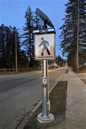 NEW UPGRADED CROSSWALKS
The City has upgraded the crosswalks at ERT / Evergreen and ERT / Maple. The upgraded crosswalks feature rapid rectangular flashing beacons, or RRFBs. These are successfully used in other communities on Vancouver Island as a means of making the crosswalk safer for pedestrians. Just like the existing 12” flashing amber lights, RRFBs are solar powered.
2022 TRANSPORTATION PROJECTS
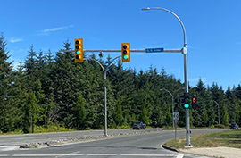 S. DOGWOOD STREET / S. ALDER STREET: NEW TRAFFIC SIGNAL
The City has installed a new traffic signal at S. Dogwood Street and S. Alder Street. This will improve safety for both vehicles and pedestrians. The signal will include a left turn arrow from southbound on S. Dogwood Street, pedestrian walk / don’t walk indications, emergency vehicle pre-emption and an uninterruptible power supply. The project is paid for by Couverdon (developer of Jubilee Heights), the City, and ICBC. The signal has been installed and drivers are reminded to pay attention and obey the lights.
 S. DOGWOOD STREET / ERICKSON ROAD: NEW CROSSWALK
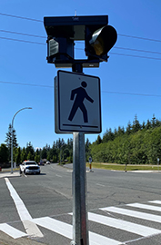
The City has installed a new pedestrian crosswalk with flashing amber lights at S. Dogwood Street and Erickson Road. This will improve safety and accessibility for pedestrians. Drivers are reminded to pay attention to pedestrians wanting to cross the road. The crosswalk has been installed and drivers and pedestrians are reminded to drive and walk safely.
HILCHEY BIKE LANES
To encourage cycling, the City of Campbell River has installed bike lanes on Hilchey Road, from Highway 19A to South Dogwood Street. The east and westbound bike lanes connect the multi-use path along South Dogwood Street to the Seawalk along Highway 19A. They pass Timberline Village, Penfield Elementary School, and near the Sportsplex with the skate and bike park.
HIGHWAY 19A BUS BAY PULL-OUTS IN THE REGIONAL DISTRICT
Under a cost share agreement with the BC Ministry of Transportation and Infrastructure, the City has installed bus bay pull-outs along Highway 19A at four locations in the Strathcona Regional District. The City operates the Transit system within City limits, as well as along Highway 19A to Oyster River, where passengers can transfer to the Comox Valley system.
The four locations with new bus bay pull-outs are:
- Highway 19A, northbound, at York Road
- Highway 19A, southbound, at York Road
- Highway 19A, southbound, at Seawave Road
- Highway 19A, northbound, at Hernando Road
CONTACT INFORMATION
For additional information about construction updates, please contact:
City of Campbell River Transportation Department
Phone: 250-286-5700
Email: transportation@campbellriver.ca
Address: 301 St. Ann's Road, Campbell River, BC V9W 4C7